General
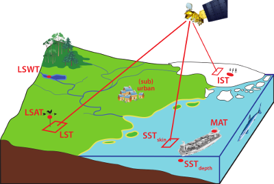
The relevance of surface temperatur (ST) to human life motivated the meteorological measurement of surface air temperature (SAT) during the historical past, with widespread reliable data from the early 18th century. Over the oceans, measurements of both sea surface temperature (SST) and marine air temperature (MAT) were made from naval and voluntary observing ships. Global mean ST has been estimated by aggregating in situ SAT and SST measurements for the period since the mid 19th century. This time series has become a high-profile index of anthropogenic climate change.
Historical SAT and SST observations present challenges of extremely uneven sampling, of reconciling measurements made by different technologies and protocols, and of quality control (QC) (e.g., weather station moves), transcription errors, lack of metadata, etc.
Similar challenges occur in linking in situ to satellite measurements over all domains. Issues of sampling differences and geophysical differences between near-surface layer temperatures and radiometric temperatures will require collaborative research and new approaches.
Sea surface temperature
There has been a high level of international co-operation on satellite SST and analyses, via the Group for High Resolution Sea Surface Temperature (GHRSST). GHRSST productively focussed on operations, data and resource sharing. GHRSST has also stimulated advances in relating satellite and in situ SSTs, diurnal variability, and integrated use of the full constellation of observations. In Europe, new approaches to satellite SST have yielded increases in accuracy, through the OSI-SAF and the ATSR Reprocessing for Climate (ARC). This continues through the ESA SST Climate Change Initiative. The best satellite SSTs are now of comparable point accuracy to drifting buoys, emphasising the need to treat in situ and satellite observations as a joint system, both for operations and climate. GHRSST and JCOMM are jointly pursuing experimental upgrades to the drifting buoy network. Considerable effort has been invested in homogenising and QC-ing the historical in situ observational record. Challenges include the radical shift from ship-domination to drifting-buoy domination of in situ SST since 1980. This is suspected to have caused underestimation of global warming over that period.
Arctic
Despite the above efforts, SST at high latitudes remains problematic, because of challenging conditions for remote sensing and sparse in situ observation. We propose in this network to focus a case study on the Arctic latitudes. Operational SST observation over the Arctic Ocean affects forecasting skill in the northern midlatitudes, and reducing uncertainties in satellite SSTs across the Arctic is a priority. There are also challenges for climate analysis from data sparsity. In analysing SAT over Arctic land areas, one either ignores areas without in situ measurements (as in HadCRUT312) or makes long-distance extrapolations that can also extend over ocean and sea ice (as in GISTEMP). Discrepancies between these approaches matter particularly because warming in the Arctic over recent decades has been around twice the global average (IPCC AR4). Even establishing a reference against which to monitor change is problematic. SST, SAT, or ice ST anomaly all behave differently, and there is no consensus on dealing with areas that were formerly ice-covered. There is a pressing need to explore alternatives to evaluating ST change in the Arctic.
Land surface temperature
Land surface temperature (LST) (from satellite) has greater uncertainty than SST, mainly because of emissivity variations with wavelength, view angle and surface changes in vegetation or snow cover. LST varies relatively rapidly compared to SST or SAT, because of the low effective heat capacity per unit area of land surfaces. These factors make LST harder to use within forecasting operations or to form climate analyses. Nonetheless, there are strong scientific and operational drivers to advance exploitation of LST in conjunction with SAT measurements. One is the spatial detail available from satellites, which allows mapping of ST variations down to urban scales.
Another is lack of in situ measurements. Here, we propose to include a focus on a region of Africa, which is particularly sparsely observed in situ. However, Africa is viewed every 15 minutes by the SEVIRI instrument on a geostationary satellite, in addition to being overflown by polar orbiting sensors capable of LST. Can the satellite LSTs complement the sparse in situ measurements to yield an improved regional SAT analysis? There has been significant progress on LST and its uncertainty in the region, yet the difficulties mentioned above have not been fully overcome. From a climate perspective, an important opportunity is to use satellite LST to inform homogenisation of in situ measurements (e.g., minimising discontinuity when a weather station changes location). This is a significant issue within the surfacetemperatures.org initiative, and an LST-based approach is seen as complementary to planned activity, giving a valuable alternative check on conventional methods. A range of expertise and approaches is needed to accelerate progress on these questions.
Re-analysis
Re-analysis products give fields of SAT using weather forecasting models constrained by different types of observations, including SST and in situ SAT at station locations (among many others). This proposal links to EURO4M, which is a re-analysis project for the European region. We will also include data from the ECMWF re-analysis. Comparisons of different estimates are informative about errors, in observations or re-analyses. Insights will ultimately feed back into improved treatment of ST variables in re-analysis.